← Home · Geophysics

Electrical Resistivity Surveys (VES) for Site Investigation in Murfreesboro

Together, we solve the challenges of tomorrow.

EXPLORE →

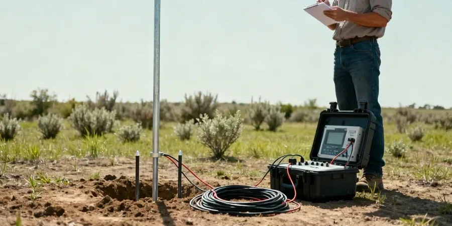
A common mistake we see in Rutherford County is assuming uniform soil conditions between boreholes. Murfreesboro sits on a complex mix of Ordovician limestone residuum and alluvial deposits along the Stones River, and a standard SPT alone won't catch a five-foot-wide solution cavity ten feet down. Electrical resistivity / VES (Vertical Electrical Sounding) fills that gap. By injecting current into the ground and measuring the voltage response at increasing electrode spacings, we build a continuous 2D profile of the subsurface—highlighting clay lenses, fractured bedrock, or water-saturated zones that could destabilize a footing. When combined with SPT drilling to calibrate the resistivity units against actual soil samples, the result is a ground model that makes sense geologically, not just statistically.

Resistivity imaging catches what borings miss: the continuous profile between drill points that reveals hidden cavities, clay seams, or perched water.

Scope of work

Soil conditions shift dramatically across the city. North of Medical Center Parkway, you'll often encounter the Lebanon Limestone formation with thin silty clay overburden—resistivity values here typically exceed 200 ohm-m, indicating competent rock. But down toward the Stones River floodplain near Old Fort Park, the profile changes to thicker alluvium and higher moisture content, with resistivity dropping below 40 ohm-m in saturated silts. This contrast matters for foundation design. A VES array configured with Schlumberger geometry can map this transition before excavation begins. For projects dealing with variable bedrock depth, pairing the resistivity profile with a seismic refraction survey gives both the velocity-based rippability and the electrical signature of the material—two independent checks that reduce the risk of surprises during grading.
Electrical Resistivity Surveys (VES) for Site Investigation in Murfreesboro
Technical reference image — Murfreesboro

Area-specific notes

The field setup involves a multi-electrode cable system, usually 28 to 56 stainless steel stakes pushed a few inches into the topsoil, connected to a resistivity meter that cycles through a programmed sequence of current injections. In Murfreesboro's summer heat, dry surface soils can create high contact resistance that degrades data quality—our team compensates with saline solution at each electrode and monitors contact resistance in real time before each cycle. The biggest risk we mitigate isn't equipment failure; it's misinterpretation. A low-resistivity anomaly could be a water-filled void, or it could be a clay-filled depression in the bedrock. Without a borehole or test pit correlation nearby, the interpretation remains ambiguous. That's why every VES report we deliver in Murfreesboro includes a discussion of equivalence and suppression—because telling a client the ground is uniform when it isn't is worse than saying nothing at all.

Need a geotechnical assessment?

Reply within 24h.

Email: contact@geotechnicalengineering.biz

Technical parameters


ParameterTypical value
Array ConfigurationSchlumberger and Wenner; dipole-dipole for 2D profiling
Maximum Depth of InvestigationTypically 30–60 m (100–200 ft), depending on spread length
Typical Resistivity Range (Limestone)150–500+ ohm-m for intact Ordovician limestone
Typical Resistivity Range (Clay/Silt)20–60 ohm-m for saturated residual clays
StandardASTM D6431-18
Data Inversion MethodL1-norm (solid) and L2-norm (smooth) inversion

Linked services

01

Karst and Void Detection Surveys

Murfreesboro's limestone geology carries a real karst hazard. We use high-resolution 2D resistivity lines on a 10–15 ft electrode spacing to image cavities, soil arches, and raveling zones before foundation construction. Each profile is inverted with topography correction and calibrated against available boring logs.

02

Groundwater and Stratigraphic Profiling

For sites near the Stones River or its tributaries, we run longer Schlumberger soundings to map the water table, clay aquitards, and the transition from alluvium to bedrock. This data feeds dewatering plans, infiltration basin design, and basement waterproofing strategies.

Standards used


ASTM D6431-18 — Standard Guide for Using the DC Resistivity Method, IBC Chapter 18 — Soils and Foundations, ASCE 7 — Minimum Design Loads and Associated Criteria for Buildings

Q&A

How deep can a VES survey investigate in Murfreesboro's geology?

With a maximum current electrode spacing of 600 feet (AB/2 = 300 ft), the effective depth of investigation reaches roughly 100 to 150 feet in the limestone residuum, provided the target has sufficient resistivity contrast. In conductive clay-rich soils, the depth of signal penetration decreases, and we adjust the spread accordingly. For deeper targets beyond 150 feet, we typically combine VES with seismic refraction to constrain the interpretation.

What does a VES survey cost for a typical residential lot in Murfreesboro?

For a standard residential or small commercial lot, VES surveys in Murfreesboro run between US$630 and US$940, depending on the number of soundings, the array length required to reach target depth, and site access conditions. A proposal always follows a quick site walk because steep terrain or dense brush affects the setup time.

How do you validate the resistivity results?

Resistivity is a non-unique geophysical method—different subsurface models can produce the same measured curve. We validate by tying each resistivity profile to at least one point of ground truth, usually an SPT boring or a test pit. The boring log provides the layer thicknesses and material types that constrain the inversion model, converting a mathematically possible solution into a geologically probable one.

Location and service area

We serve projects across Murfreesboro and its metropolitan area.

View larger map