← Home · Geophysics

Seismic Tomography (Refraction & Reflection) in Murfreesboro, TN

Together, we solve the challenges of tomorrow.

EXPLORE →

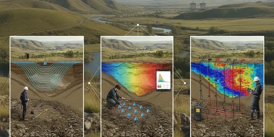
Murfreesboro sits on a karst bedrock surface carved into the Ordovician Ridley and Lebanon limestones, part of the Stones River Group. The depth to competent bedrock varies wildly here—15 feet under the old courthouse square, 80 feet or more near the West Fork Stones River. That irregular rockhead, combined with solution cavities from centuries of groundwater flow, makes seismic tomography indispensable for any project larger than a single-family home. MASW surveys give us shear-wave velocity profiles for site class, but they don't image the bedrock surface with the same lateral resolution that refraction tomography provides. We run 24- or 48-channel spreads with a 5-meter geophone spacing, hitting the line with a sledgehammer on a steel plate and processing first breaks through iterative ray-tracing algorithms. The result is a velocity cross-section showing soil overburden, weathered rock, and competent limestone—critical data for footing design, retention basin siting, and IBC Chapter 18 compliance.

In karst terrain, refraction tomography doesn't just find bedrock—it identifies the traps: velocity inversions where soft clay masks a void beneath.

Scope of work

ASCE 7-22 Table 20.3-1 assigns Murfreesboro a default Site Class D unless proven otherwise through geophysical investigation. That default carries a 1.2x penalty on short-period spectral acceleration compared to Site Class C—enough to swing a steel frame design by thousands in tonnage. Reflection tomography steps in when refraction hits a velocity inversion, which happens often here where soft clay-filled sinkholes underlie stiff residual clay. We use common-midpoint stacking with a 24-channel land streamer and an accelerated weight drop source, processing the data through standard NMO correction and stacking workflows adapted from ASTM D7128 guidance. The combination of refraction for bedrock depth and reflection for cavity imaging gives the structural engineer a defensible basis for reducing the site coefficient. For roadway projects, we correlate the tomographic profiles with CBR testing to map subgrade stiffness along proposed alignments without opening 20 test pits.
Seismic Tomography (Refraction & Reflection) in Murfreesboro, TN
Technical reference image — Murfreesboro

Area-specific notes

A medical office building off Thompson Lane ran into a textbook karst problem in 2022. Standard borings hit refusal at 22 feet on three of five locations—looked like uniform shallow bedrock. The structural engineer designed spread footings at 18 inches embedment. During excavation, the contractor punched through a clay-filled sinkhole between two borings; the hole swallowed 12 cubic yards of flowable fill before stabilizing. A two-day seismic tomography survey beforehand would have cost under $5,000 and flagged the velocity inversion immediately. This is the risk pattern we see repeatedly across Rutherford County: discrete boreholes miss lateral variability, and the cost of remediation during construction runs 10 to 20 times the cost of a geophysical survey. Reflection tomography is the only surface method that reliably images these buried voids before the backhoe finds them first.

Need a geotechnical assessment?

Reply within 24h.

Email: contact@geotechnicalengineering.biz

Technical parameters


ParameterTypical value
MethodSeismic refraction and reflection (P-wave and SH-wave)
Geophone spread24 to 48 channels, 2.5 to 10 m spacing
Source typeSledgehammer, accelerated weight drop, or Betsy Seisgun
Depth of investigation15 to 120 ft depending on spread length and source energy
Data processingIterative ray tracing tomo (refraction), CMP stacking (reflection)
Reporting standardASTM D5777 (refraction), ASTM D7128 (reflection)
Typical deliverablesVelocity tomograms, interpreted bedrock surface, cavity anomaly maps

Linked services

01

Refraction Tomography for Bedrock Mapping

24- to 48-channel P-wave refraction lines processed with iterative ray-tracing software. We deliver velocity cross-sections with interpreted top-of-rock surface, rippability classification, and IBC site class recommendations. Typical line length 115 to 230 feet, with 5-meter geophone spacing for commercial building pads and retention ponds.

02

Reflection Tomography for Cavity & Fault Detection

High-resolution CMP reflection surveys using a land streamer array and accelerated weight drop. Targets depth range 20 to 100 feet—the critical zone for sinkhole development in Murfreesboro's karst. Processing includes NMO correction, stacking, and migration; anomalies are cross-checked against available boring logs.

03

Combined Refraction-Reflection for Critical Structures

Integrated survey package for hospitals, schools, and mid-rise structures where site class reduction has major structural cost implications. Refraction gives the velocity model; reflection overlays structural detail on the bedrock surface. Includes Vs30 estimation from MASW or downhole correlation when required by the geotechnical engineer of record.

Standards used


ASTM D5777-18 (Seismic Refraction for Subsurface Investigation), ASTM D7128-18 (Seismic Reflection for Shallow Applications), ASCE 7-22 Chapter 20 (Site Classification Procedure), IBC 2021 Section 1613 (Earthquake Loads—Site Coefficients), TDOT Standard Specifications Section 206 (Geotechnical Exploration)

Q&A

How deep can seismic tomography investigate in Murfreesboro's limestone?

Refraction tomography with a 230-foot spread and sledgehammer source typically resolves to 60-80 feet depth in weathered limestone. With an accelerated weight drop and 48 channels over 470 feet, we reach 100-120 feet. The limiting factor isn't the equipment—it's the velocity structure. If sound limestone lies shallow, energy refracts along that horizon and deeper features go unresolved. That's when we recommend supplementing with a reflection line to image cavity zones below the first competent reflector.

What does a seismic tomography survey cost for a typical Murfreesboro commercial lot?

The reference range for this service in Murfreesboro is US$2.680 - US$5.590. The final price depends on the project scope and volume.

Can tomography replace soil borings for IBC site classification?

No—and we tell every client this upfront. Seismic tomography measures velocity, which correlates to stiffness and rock quality, but it doesn't give you soil type, moisture content, or Atterberg limits. IBC Section 1613 requires borings or in-situ tests to confirm site class. Tomography fills the gap between borings: it shows what the subsurface does laterally, catching the velocity anomalies that discrete borings miss. The strongest submittal to the building official pairs 2-3 borings with a refraction line that ties them together.

Location and service area

We serve projects across Murfreesboro and its metropolitan area.

View larger map